Picturing Places at The British Library: Georgian Places
The British Library has announced the launch of Picturing Places, a new free online resource which explores the Library’s extensive holdings of landscape imagery.
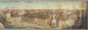
PANORAMIC VIEW of that part of Ratisbon west of the cathedral, painted in water-colours by G. Scharf, sen.; 1845. Paper; 6 ft. 1/2 in. X 1 ft. © British Library
Picturing Places will help researchers interested in the Georgian period to visualise the eighteenth century more clearly. One of the leads on the project, Felicity Myrone at the British Library, was recently a King’s Research Fellow on the Georgian Papers Programme. Felicity’s project is focused on the topographical map collection of George III and this work contributed to the Picturing Places resource.
The British Library’s huge collection of historic prints and drawings is a treasure trove waiting to be discovered. Picturing Places showcases works of art by well-known artists such as Thomas Gainsborough and J.M.W. Turner alongside images by a multitude of lesser-known figures. Only a few have ever been seen or published before.
This is the first time that a large and important body of such materials from the Library are being brought to light. While landscape images have often been treated as accurate records of place, this website reveals the many different stories involved – about travel and empire, science and exploration, the imagination, history and observation.
As well as over 500 newly-digitised works of art from the collection, this growing site will feature over 100 articles by both emerging and established scholars from many disciplines. As part of the British Library’s ongoing Transforming Topography research project, films from the Library’s 2016 conference exploring the depiction of place are also accessible, providing revelatory insights about the history of landscape imagery.
Moreover, the Picturing Places project emerged out of two larger programmes of ongoing research at the British Library that may be of interest to Georgian researchers.
King’s Topographical Collection Cataloguing and Digitisation
Perhaps most significantly, there is the King’s Topographical Collection Cataloguing and Digitisation. George III’s extensive ‘K.Top’ collection of around 30–40,000 maps and views reflects changing impressions of place and space across the 16th–19th centuries through manuscript and printed atlases; architectural drawings and garden plans; maps and records of military campaigns, fortifications, barracks, bridges and canals; records of town and country houses, civic and collegiate buildings; drawn and printed records of antiquities including stained glass, sculpture, tombs, mosaic pavements and brasses; and thousands of drawn and printed views.
The collection includes the work of familiar names from Hollar to Hawksmoor, alongside the works of a host of lesser-known artists and amateurs and much anonymous or unidentified material. The British Library has received support from a number of generous donors to make this material available digitally.
The core aim of the ongoing King’s Topographical Collection Cataloguing and Digitisation Project is to provide free online access to George III’s maps and views. The main outputs are the ongoing creation of detailed and searchable catalogue records on the Explore catalogue and high quality digital images, which will be available there in 2018. This project has also involved sharing our records with other institutions and initiating research projects.
A 2017 PhD placement will initiate the study of George III’s parallel collection of sea charts and atlases. This project will be known as the King’s Maritime Collection.
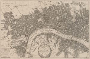
A pocket map of the citties of London, Westminster, & Southwark: with the addition of the new buildings to this present year 1725. Thomas Bowles. © British Library
Transforming Topography
Secondly, there is broader work on understanding the relationship between society and the landscape. This is being explored in the Transforming Topography project.
Topography is an emerging and dynamic field in art historical scholarship. The core aim of the Transforming Topography research project is to stimulate research in this often-overlooked field. It presents topographical art as complex imagery which needs to be explored and understood in relation to the shifting motives of all those involved in its creation.
Rather than seeing topographical art as marginal compared to the landscapes in oils or watercolours by the canon of ‘great artists’ or more imaginative and Sublime images, a growing number of scholars are embracing the historical study of images of specific places in the graphic arts. This is sparking a lively debate around nationhood, identity, and cultural value, or what John Barrell describes as ‘the conflict and coexistence of the various… “stakeholders” in the landscape and in its representation’ (Barrell, Edward Pugh of Ruthin, 2013).
Our collection holds the world’s most extensive and important collection of British topographic materials: from handwritten notes by antiquarians to rare first editions, extra-illustrated books and unique compilations of plates, text and drawings by named collectors. The full extent and depth of the collections are only now being properly recognised and explored.